Since gaining independence in 1960, the Central African Republic (CAR) has been fraught with persistent political corruption and a series of violent coups. Most recently, in March 2013, a coalition of Muslim rebel groups called the Seleka ousted President François Bozizé for his failure to follow through on the settlement ending the Bush War in 2007. The Selekaovertook of the capital, disregarding a January 2013 ceasefire agreement and installing Michel Djotodia as interim president. Djotodia has been ineffective in controlling the restless Seleka. Village-level self-defense groups have joined members of the Central African Armed Forces and Presidential Guard to form the Christian Anti-Balaka militias and engage in countless human rights abuses.
Despite the immediacy of the crisis, the international community has been late and limited in its response. The cost to citizens of the CAR for this inaction is high – an estimated 25% of the population has been forcibly displaced and 50% is in need of humanitarian assistance.
The extent of the need and limited resources makes understanding how humanitarian assistance is being distributed in the Central African Republic even more critical. What is the local geography of the conflict and how closely is humanitarian assistance being routed to affected communities? To answer this question, I mapped the locations of recorded casualties using 2013 ACLED conflict data and the communities receiving humanitarian assistance using 2013 data from the Financial Tracking Service.
The results of this analysis are seen in the map below. Conflict points are sized according to the number of casualties associated with a given conflict event. Each prefecture is shaded with reference to aid dollars received, with darker shades corresponding to higher numbers of dollars.
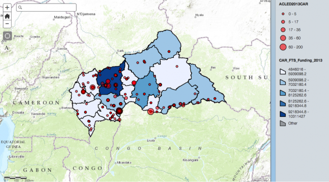
Locations of Casualties and Allocation of Humanitarian Assistance, 2013
What can we take away from this map? The targeting of humanitarian aid is not consistently following the areas of conflict. While the conflict-prone Ouham prefecture received the most aid, other similarly violent prefectures bordering Ouham to the south and west received far less aid. The capital Bangui is an epicenter of conflict, marked by several concentric bubbles, but it is located in a prefecture that receives a lower amount of aid. Notably, relatively calm northeastern prefectures appear to have received greater aid than the more violent western prefectures.
A second map below offers additional insights by looking at the difference between the percentage of aid received by a prefecture and the percentage of deaths compared to the country overall. Using the deviation of subnational aid distribution from an “ideal” one-to-one ratio, we can assess whether a prefecture is receiving more or less aid than is proportionate to the number of casualties in the region.
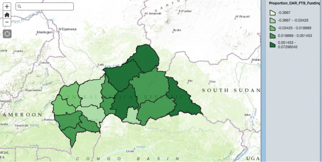
Difference between Percentage of Aid Allocated to Prefecturesand Percentage of Overall Casualties, 2013
If we assume that number of deaths should be a legitimate factor in aid allocation, two interesting observations emerge from the map above. The eastern prefectures tend to receive more aid than appropriate. Despite receiving the greatest number of aid dollars, the Ouham prefecture is still the most underfunded. Clearly donors are not allocating aid directly to where conflict is occurring.
This analysis is revealing, but there are many factors that determine aid distribution. Thousands of displaced people have moved to refugee centers that may be located away from the original conflict sites in CAR, and are likely targeted by donors in this way. Perhaps aid dollars are being allocated to ongoing projects unrelated to the current conflict.
Nonetheless, looking at the geography of conflict and the distribution of aid in CAR raises an important question: why is it that humanitarian aid does not appear to be getting to the most conflict-prone regions? This spatial analysis is a starting point, but further analysis is needed to provoke a meaningful discussion among donors and leaders about future aid allocation in the country.