In the first post of this blog series, we discussed how our partnership with USAID’s Global Development Lab has catalyzed a global movement to generate hyper-local data for decision-making and analysis. AidData now works with more than a dozen partner governments and various development partners to sub-nationally track the distribution of nearly $650 billion in global development finance. But the provision of data alone will not save or substantially improve lives. Development policymakers and practitioners have to actually use these rich, subnational data when they are making decisions about how to allocate development dollars. And civic monitors need to be able to track funding in their local communities and sound the alarm when projects and programs are not delivering their intended results. Today, we briefly describe some of the research and technical activities that support our partners to make meaning out of data.
In the first year of our work with USAID’s Global Development Lab, AidData launched the 3.0 version of its web portal which enables policymakers and practitioners to compare data on over $40 trillion in development finance- including aid from 90 donor agencies, remittances, foreign direct investment, and US private foundation giving- in one interactive interface.
The AidData Center for Development Policy also developed an interactive GIS Portal as part of the Aid Management Platform (AMP). The AMP is used by more than 25 country governments, and thus far the new GIS tool has been rolled out to ten ministries of finance and planning, - assisting both those within the AidData - GDL partnership, as well as the network of AMP countries writ large. Together, AidData 3.0 and the AMP GIS portals were accessed by 135,000 users last year.
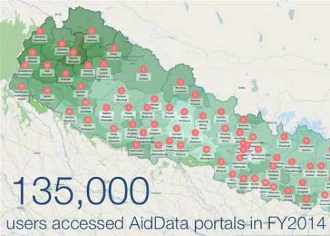
Map created on Nepal’s Aid Management Platform.
To visit the online portal, click the picture.
And we have seen how early adopters can use these tools to improve development decision-making. With their aid portfolio geocoded and visualized in the GIS portal, Nepal’s Ministry of Finance was able to determine that the Far Western development region of Nepal -- one of the poorest regions of the country -- was relatively underserved by development activities. They have used this information to inform their discussions with donors to advocate for more funding for the Far Western region.
In Timor-Leste, the Ministry of Finance used the geocoded data to produce donor allocation profiles in their Development Cooperation Report, and the Korea International Cooperation Agency (KOICA) reported that they use the geocoded data as a first step in coordinating with other donors, identifying who is working in which sectors and geographic areas in order to coordinate specific interventions.
AidData has also helped accelerate the uptake of geocoded aid information by researchers who want to better understanding the subnational targeting and impact of development funding. To accomplish this, we convened the AidData Research Consortium (ARC) at the start of 2014 -- a network of 90 researchers from a variety of disciplines -- united by their interest in producing policy-relevant research using geocoded aid information.
One particular methodological approach being pursued by various members of ARC -- spatial impact evaluation -- has found broad application in various countries and sectors and captured the attention of development policymakers and practitioners. This quasi-experimental impact evaluation method brings together sub-national outcome measures from satellites, household surveys, and census data with geocoded aid information to rigorously evaluate the impact of development interventions -- and often at a lower cost and faster speed than traditional randomized control trials.
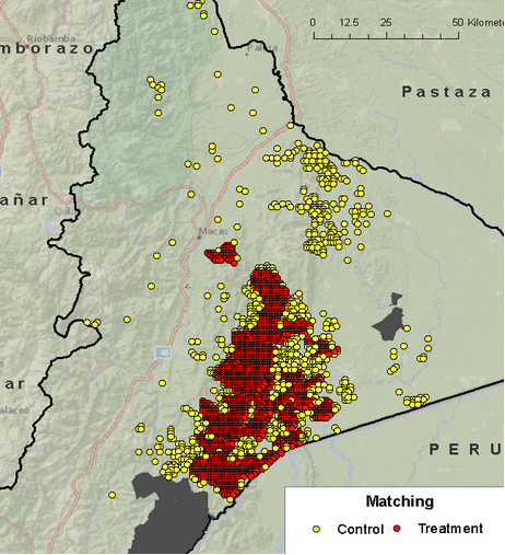
Map of the USAID Ecuador land management program (Source: Buntaine, Hamilton, and Millones 2015)
ARC researchers Mark Buntaine, Stu Hamilton, and Marco Millones initially used this method to evaluate a USAID/Ecuador land management program. ARC members Mike Findley and Joe Young have also recently launched a collaboration with USAID/Colombia to use geospatial impact evaluation methods to evaluate the effectiveness of a flagship municipal governance program. Dan Maliniak, another ARC member, is working with USAID/Georgia to rigorously evaluate an e-governance program. USAID’s decision to invest in geospatial impact evaluation methods “ahead of the market” has had a catalytic effect among other donors, leading other donors such as Germany’s KfW and the MacArthur Foundation to follow suit.
Other innovation investments of the partnership have focused on the development of decision support technologies to enable high-powered users to make tactical and allocation decisions using geocoded aid information, and AidData is currently constructing prototype decision making tools and spatially-enabled real-time databases as proofs-of-concept. Over the course of this summer, we will be announcing additional research activities supported by USAID and the Global Development Lab.
These innovations will enable development policymakers practitioners to better allocate, coordinate, and evaluate scarce aid resources. And in our next post next Wednesday, we’ll talk about the ecosystem of partners that we hope will help scale these innovations.

