Last week, the United Nations University World Institute for Development Economics Research released a working paper about AidData’s pilot study to “ground-truth” the existence of development projects in South Africa and Uganda funded by the Chinese. While the pilot was successful in verifying many projects remotely identified using AidData’s Tracking Under-Reported Financial Flows (TUFF) methodology, training enumerators and conducting site visits are time and resource intensive. This prompted AidData to iterate less resource intensive methods to verify project entries in china.aiddata.org. Skytruthing – using satellites to remotely monitor the status of large, visible projects from the sky – is one promising approach that we think could find useful applications in many parts of our work.
Several AidData researchers have recently begun using satellite imagery services, such as Google Maps and Google Earth, to locate and monitor changes in Chinese infrastructure projects built in African countries. After reviewing a project description on china.aiddata.org, researchers often use Google Maps to scan for and locate physical structures, like presidential palaces, ministerial buildings, or highways. The project descriptions often place these structures within specific neighborhoods that a researcher can scan visually.
After locating a project, the researcher can plug its coordinates into Google Earth in order to view satellite images of the terrain. Google Earth’s time slider tool allows one to review satellite images from previous years, enabling the user to track construction of a project over time.
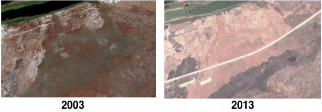
These images, found using Google Earth's time slider tool, display the Renk-Malakal Road in Sudan. In 2003 (left), no road appears in the image. In 2013 (right), the white line down the middle of the photo is the road financed by the Chinese.
The Google Earth interface also allows users to view any geo-tagged photos near a specific location, providing additional project information.
Our AidData-China team has employed both ground-truthing and skytruthing techniques in order to provide an additional layer of scrutiny to the project entries on china.aiddata.org. However, each method has trade-offs. Ground-truthing can add value and improve user confidence in the accuracy of development project locations that are identified remotely, but the approach is expensive and time intensive. Skytruthing, on the other hand, can be undertaken with fewer resources, but this method relies on satellite coverage that may be distributed unevenly across a region and satellite images that may have low resolution.
Chinese development finance is particularly well suited to skytruthing because China funds many large infrastructure projects (e.g., hospitals, roads, government complexes, stadiums). For many African countries, Chinese-financed stadiums are among the most costly and highest profile infrastructure projects in their portfolio. As a result, our first tests of the skytruthing method involved collecting satellite images of all Chinese built stadiums identified in the Chinese Development Finance in Africa dataset.
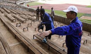
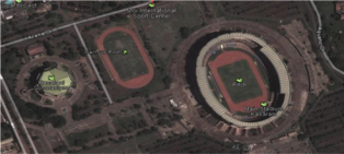
Moi International Sports Complex (right) in Nairobi, Kenya was originally built in 1987 by China for the All Africa Games. In 2010, Shengli Engineering was contracted to refurbish the stadium. The Chinese Ministry of Commerce funded the renovations through a monetary grant (project ID #1265). This project is number 16 on the story map tour.
Stadium construction is a hallmark of China’s engagement in Africa, perhaps because it involves building something tangible that enhances China’s reputation among African citizens, while providing a service that China’s own state-owned firms are well equipped to execute. The story map created with Esri Story Map templates below provides a high-resolution satellite image tour of 18 Chinese financed stadiums in Africa uncovered during the pilot. Together, these stadiums account for over $540 million in development finance investments. Each stop along the tour provides a link back to the relevant project page on china.aiddata.org.

Skytruthing holds great promise as an innovative method to verify the status of development projects identified remotely using the TUFF methodology. Check back with us in the coming months for more updates on this methodology and our china.aiddata.org database.